REVIEW · SAN DIEGO
Beaches & Bluffs San Diego’s Ultimate Coastal Driving Tour
Book on Viator →Operated by Drives & Detours · Bookable on Viator
San Diego’s coast is best in slow motion. This self-guided coastal drive stitches together big-picture views and small “pull over here” moments, with an app that talks while you roll. I especially like how it gives you clear, scenic stop logic and how many stops are genuinely worth getting out for.
I also like the value math: $11.99 per group (up to 5) for an audio-guided route packed with iconic locations and practical pointers along the way. The tour setup is flexible too, with unlimited access within 30 days, so you can replay the drive later.
One thing to keep in mind: the app is not a full turn-by-turn GPS replacement. If you want maximum ease, you’ll likely do best with a designated navigator and your own backup navigation plan.
In This Review
- Key things I’d circle on this coastal drive
- How a self-guided coastal route beats guessing your way around
- Price and what $11.99 per group really buys you
- The app experience: audio and route pins, not full GPS control
- Stop 1: Torrey Pines State Beach for the iconic cliff-and-ocean photo
- Torrey Pines Natural Reserve: free entry, parking is the one tradeoff
- Torrey Pines Gliderport: paragliders and a real decision point
- Right by the water: Birch Aquarium as a “maybe” stop
- La Jolla Shores Park: getting the lay of the land
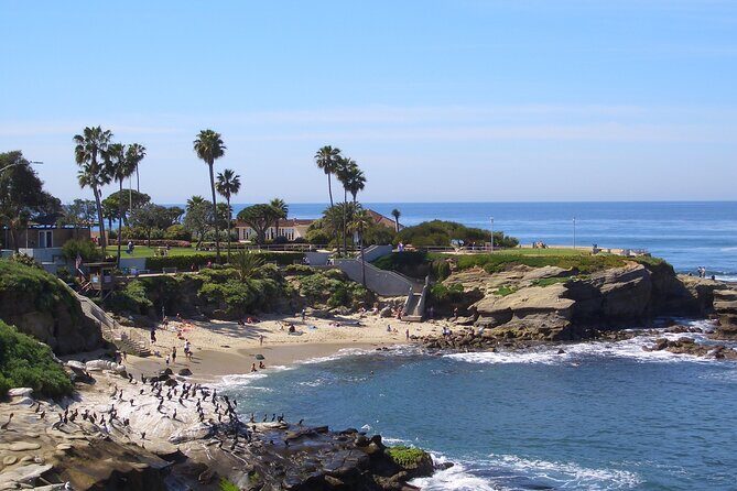
- La Jolla Cove along Coast Blvd: the coastal town vibe in motion
- Mt. Soledad National Veterans Memorial: panoramic viewpoints with minimal time cost
- Bird Rock coffee, Pacific Beach energy, and Mission Beach differences
- Ocean Beach: Dog Beach and OB Pier with a funky local feel
- Sunset Cliffs Natural Park: a drive that’s basically a moving viewpoint
- Point Loma finish near Cabrillo: best views, plus an optional early add-on
- How long should you budget: don’t just plan 3 hours
- Who this coastal drive suits best
- Final thought: Should you book it?
- FAQ
- How much does Beaches & Bluffs San Diego’s Ultimate Coastal Driving Tour cost?
- How long does the tour take?
- Where does the tour start and end?
- Is admission included for the stops?
- What’s included in the price?
- Do I need a smartphone?
- What times does the tour run?
- Is free cancellation available?
Key things I’d circle on this coastal drive

- Torrey Pines State Beach photo stop: built for the classic bluff-and-surf perspective
- Torrey Pines Natural Reserve easy hike option: free entry, with parking reality in mind
- La Jolla to La Jolla Cove: a quick hit of coastline plus ideas for where to eat and wander
- Mt. Soledad Veterans Memorial viewpoints: panoramic landmarks without a long detour
- Pacific Beach, Mission Beach, Belmont Park: the drive picks up the beach-culture energy fast
- Point Loma finish near Cabrillo: prime coastal views, with an optional early sprint to Cabrillo
How a self-guided coastal route beats guessing your way around
This tour works because it’s built for real driving days, not fantasy sightseeing. You get a pre-set route linking the most photogenic parts of San Diego’s northern coast, plus the in-between neighborhood flavor that makes the trip feel local.
Instead of hopping randomly, you’ll follow an audio-guided rhythm: drive, pull over, step out, then back in the car. That keeps your day from turning into a parking-lot scavenger hunt.
Other San Diego tours we've reviewed in San Diego


Price and what $11.99 per group really buys you

At $11.99 per group (up to 5), you’re basically paying for a smartphone-guided plan for a half-day to full-day loop. The stops along the way are listed as admission free for multiple major viewpoints and areas, which matters because entrance fees can add up fast on self-paced trips.
Also, your app access is not a one-and-done ticket. With unlimited access within 30 days, you can reuse the route when you return for sunset, when you have better weather, or when you want to linger at one stop you rushed the first time.
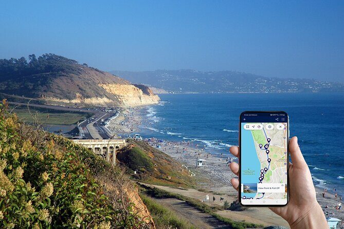
The app experience: audio and route pins, not full GPS control
The tour’s “brain” is the app download plus a mobile ticket. You’ll get audio guidance while driving and time at each stop to walk around if you want to. You can also pause and restart the experience, which is handy if you’re eating, waiting for parking, or stepping into a shop.
Here’s the practical catch: the navigation is intentionally not a complete GPS replacement. The provider disables full GPS routing because it might send you down roads that skip the scenic parts of the drive. So, use the app for the tour plan, but keep your own map app as backup—especially if a street is temporarily closed.
Stop 1: Torrey Pines State Beach for the iconic cliff-and-ocean photo
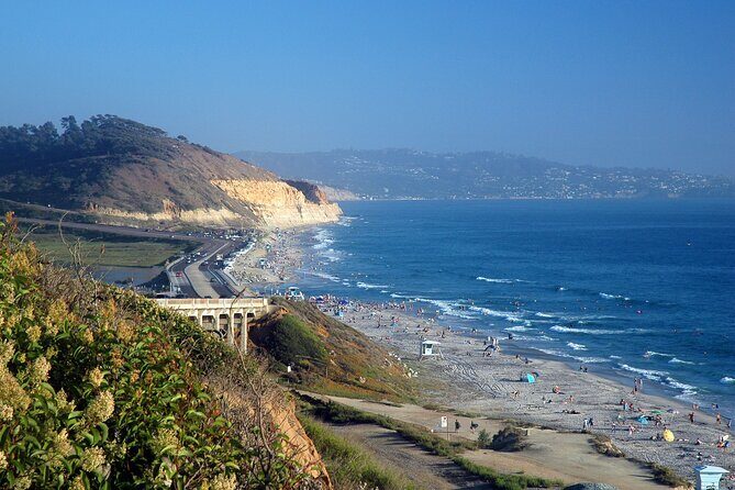
Your day starts at 2602 Del Mar Heights Rd in Del Mar, and the first highlight is Torrey Pines State Beach. This is a strong opener because the coastline here delivers drama fast: cliffs above surf, ocean light, and the kind of view that instantly makes you slow down.
The tour guidance points you to a best place to stop for an iconic picture. Spend a few minutes here even if you plan to spend more time later—early photos are easier before the light and crowds shift.
Torrey Pines Natural Reserve: free entry, parking is the one tradeoff
Next is Torrey Pines State Natural Reserve. This portion is timed for an easy hike option if you feel like stretching your legs, and the area is a great way to experience the bluffs up close without committing to a long trek.
The key detail is parking: admission is free, but parking is not included. The good news is that the tour notes free parking is available along the beach, which can save you from expensive lots if you’re willing to walk a bit. If you’re traveling with kids or anyone who prefers short distances, this is one stop where you’ll feel the value of the recommended easy hike.


Torrey Pines Gliderport: paragliders and a real decision point

Then you’re at Torrey Pines Gliderport, where you can watch paragliders launch off the cliff. Even if you don’t book anything, it’s the kind of spectacle that makes a coastal drive feel alive—people timing gusts, gear getting sorted, then the sudden lift.
The tour also gives you the option to go up on a tandem flight. If the idea appeals, this is your moment to decide based on conditions and what the operators have available. If you’re not feeling it, you can still enjoy the views from the ground.
Right by the water: Birch Aquarium as a “maybe” stop
As you keep rolling along, you’ll pass Birch Aquarium and get pointed to the entrance if you want to add it. This is a smart setup because it’s easy to decide on the fly: do you want a quick break inside, or do you want to keep the coastal air flowing?
Since the tour data doesn’t include aquarium entry, treat this as optional. If you have a limited window, it’s safer to treat it like a choose-your-own-adventure waypoint.
La Jolla Shores Park: getting the lay of the land

Your next big zone is La Jolla Shores Park, with inside guidance on what to do once you’re there. This part of the drive works well because La Jolla can feel split into multiple moods—wide sandy shoreline here, rocky coves later—and the route helps you move between them without backtracking.
A quick stop at La Jolla Shores is ideal if you want a photo, a short walk, or a calm breather before the more concentrated coastline views of the cove.
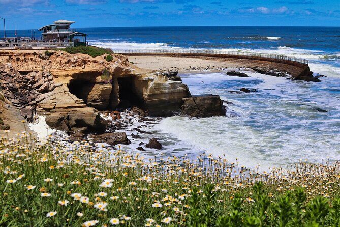
La Jolla Cove along Coast Blvd: the coastal town vibe in motion
Then comes La Jolla Cove, guided as you drive along Coast Blvd. This is one of those stretches where the “slow drive” is the point: you’re learning what makes La Jolla tick while you’re moving between overlooks and pocket areas.
The tour shares recommendations for things like restaurants and attractions, which is useful because La Jolla can be surprisingly specific. If you don’t want to waste your evening searching, having a shortlist in your pocket helps.
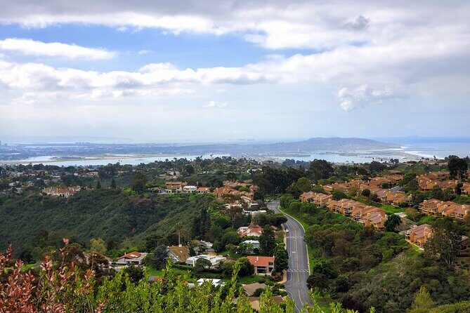
Mt. Soledad National Veterans Memorial: panoramic viewpoints with minimal time cost
At Mt. Soledad National Veterans Memorial, you get a viewpoint-style stop with spectacular panoramas. The tour is designed to show you the major landmarks you can see from the top, which turns the climb into more than just pretty scenery—you’re orienting yourself for the whole peninsula.
This stop is short (about 15 minutes in the plan), so it’s a good match for travelers who want big views without sacrificing the rest of the day. If you’re sensitive to walking uphill, park and take your time; this is worth it even if you move slowly.
Bird Rock coffee, Pacific Beach energy, and Mission Beach differences
After the viewpoints, the route shifts into neighborhoods. You’ll drive through Bird Rock and stop for coffee at a well-known local roaster—use this as your reset before the beach zones get busy.
Then the tour switches to Pacific Beach, framed as one of San Diego’s top beach destinations. Expect a more active, youth-and-sun vibe here, where the beach culture feels like it’s always in session.
A bit later you roll into Mission Beach, and the guidance explains what makes it different from Pacific Beach. You’ll also hear about Belmont Park and see the historic wooden roller coaster. If you like classic boardwalk energy and quick thrills, this is the part of the route that can turn “just driving” into a real stop.
Ocean Beach: Dog Beach and OB Pier with a funky local feel
Next is Ocean Beach, including Dog Beach and the OB Pier. This portion tends to feel more laid-back and quirky compared to some of the flashier beach names nearby, and that contrast is exactly why the route works.
The tour also points you to local restaurants and happenings in the area. Even if you don’t stop immediately, this kind of guidance helps you plan dinner before you’re tired and hungry in the wrong place.
Sunset Cliffs Natural Park: a drive that’s basically a moving viewpoint
At Sunset Cliffs Natural Park, the tour keeps you on the coastal approach down Sunset Cliffs Boulevard. This is a “keep driving, keep looking” moment—less about one single spot and more about how the coastline unfolds in layers as you pass.
If you’re the type who always misses the best view because you were busy checking the map, this stop helps because the route is already timed for attention.
Point Loma finish near Cabrillo: best views, plus an optional early add-on
Your tour finishes at the tip of Point Loma, just before the entrance to Cabrillo National Monument (entrance fee not included). The guidance has you drive past Fort Rosecrans National Cemetery and offers a view-focused ending with the possibility of seeing San Diego and Coronado Island from the coast.
If you start early enough, you can continue to the very end of the road and visit Cabrillo National Monument before it closes at 5:00 PM. There’s also a short hike option down the Bayside Trail if you want to stretch your legs and get closer to the coastline.
One practical note: the tour’s own operating hours are 6:00 AM to 4:00 PM, so if you’re late, you may only reach the Point Loma finish, not the Cabrillo add-on.
How long should you budget: don’t just plan 3 hours
The tour is listed as 3 to 6 hours, but this route rewards time. Once you start with Torrey Pines and keep going through La Jolla, Mt. Soledad, multiple beach neighborhoods, and then Point Loma, the “extra” time comes naturally.
If you want more than quick photo stops—if you’ll browse or eat or walk a bit—plan it like an entire day. You’ll have less stress, and you won’t feel rushed when one viewpoint asks for five extra minutes.
Who this coastal drive suits best
This is a great fit if you want to:
- See a lot of coastline without building a route from scratch
- Have an audio narrator guide your stops while you drive
- Mix short walks with driving, so it stays fun for different energy levels
- Enjoy beach neighborhoods plus viewpoints, not just one or two “big attractions”
It also helps if you like flexibility. The app lets you pause and restart, so you’re not trapped by a strict schedule.
Final thought: Should you book it?
Book this tour if you want a value-priced, stop-friendly coastal loop that helps you get your bearings fast and keeps you from missing the best pull-offs. It’s especially worth it when you’re traveling with a group of up to 5 people and you’d rather spend money on food and parking than on paid guided tours.
Skip it (or treat it as a light guide) if you want fully hands-off turn-by-turn navigation with no planning. In that case, you’ll still get useful guidance, but you’ll likely rely on your own navigation app anyway.
FAQ
How much does Beaches & Bluffs San Diego’s Ultimate Coastal Driving Tour cost?
It costs $11.99 per group (up to 5).
How long does the tour take?
The duration is about 3 to 6 hours.
Where does the tour start and end?
It starts at 2602 Del Mar Heights Rd, Del Mar, CA 92014, and ends at the tip of Point Loma near Cabrillo National Monument at 1800 Cabrillo Memorial Dr, San Diego, CA 92106.
Is admission included for the stops?
The tour lists free admission for many stops. Cabrillo National Monument admission is not included, and parking at Torrey Pines Natural Reserve is not included.
What’s included in the price?
You get an app and tour download, with unlimited access within 30 days.
Do I need a smartphone?
A smartphone is not included, so you’ll need one to use the app and your mobile ticket.
What times does the tour run?
The tour is available Monday to Sunday from 6:00 AM to 4:00 PM.
Is free cancellation available?
Yes. You can cancel for a full refund up to 24 hours in advance. If you cancel within 24 hours of the start time, the amount paid is not refunded.